Travel Security

Basic Travel Security Considerations

Fleet of vehicles image

With the technology that we have today, 99% of all people when going on a journey will grab a satnav, put in a postal code, or street name and city, and start their journey.

Many will either not bother, nor possess the skills to use a road atlas, in order to prepare for there journey. 

The vast majority of drivers will never think to check that there vehicle is suitable for the journey they are about to embark on, they will load up, and start the journey.

Remember the old saying” When you fail to plan, you plan to fail ” and making a journey is no different.

Before setting out on a long journey, it is advisable to do some basic checks

  • Tyres
  • Lights
  • Indicators 
  • Fuel
  • Oil 
  • water  
  • Petrol
  • Provisions
  • Screen wash 
  • Change

Basically check the car to make sure it is in a good condition for the journey you are about to embark on, and don’t  just assume that there will be no issues, and, if there is, well, not a problem, your assumption  will be simply to ring the breakdown company. 

When I am going to undertake a journey for the first time, the first thing I do is:

  • Grab a “paper-based road atlas”, yes I am old school.
  • I do a full route plan, with more than one route IE (a primary and secondary route) including the alternate times and milage variations.

Once I have a rough idea of where I am going  (the location), as well as the  area (rural or urban), a guesstimate of the time and mileage, then what I will do is some proper in-depth planning.  Usually using the RAC website, it’s a personal choice, you can use what site you choose.

  • I do an online time and milage to be precise with the exact variations.
  • I may well use street view to see the destination (if it is the first time to that location).
  • I may well look at where the parking is.
  • I will consider an alternative route (for in case there is an issue).
  • I may well workout the halfway point (depending on the distance)
  • I may well consider what the mobile reception coverage may be in that area especially if it is in a rural area.
  • I will check the car and give it a once over to make sure that there are no issues before leaving.
  • Possess an alternate phone on a different provider so I have a back up form of communication….

When I worked as a security driver, I always created a route card, and kept this with me especially when driving in another country, this replaced a road atlas, I used this for two reasons, firstly it is not always safe to stop and read a map, especially in a location you don’t know, but secondly it made it easy to keep a clear understanding of where I was going, and was I on the right road. 

When creating a route card, there is no right or wrong way to do this, it is a matter of preference, but I always kept a map in the vehicle with me, for just in-case. What I did with my route card was to pick the next major city, town or region, so that I didn’t have to read the card, just know the next location and or road number I was on and what to look out for.

Additionally, I noted what towns or areas I would pass, to help keep me orientated, if you are using a route card, then the route card needs to be simple, and easy to read.

Let’s take an example from Nottingham to Hunstanton.

Nottingham to Grantham (A52) 

(passing by: Bingham – Bottesford) 

Grantham – Kings Lynn (A52 – A17)

(passing by: Holbeach long Sutton) 

Kings Lynn – Hunstanton (A17 – A149)

(passing by: Dersingham) 

As you can see it is easy to follow, easy to use, easy to read, and you can quickly glance and know that you’re on the right route, this would be route A, if I need to change the route then I could swap as needed as I would have a B card as well just in case.

With something this simple you could have this as a backup, so, “IF”, your satnav failed IE (just stopped working, or lost the satellites) at any point on your journey, then you could quickly pull the card out, and continue on your journey, as you would be able to glance at the sign posts on the road, and your card and orientate yourself.

An example card could be, using points A, B, C and so on: 

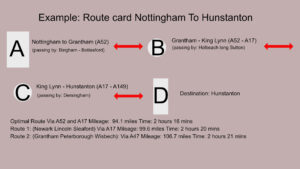
With something like this, you are breaking your journey down in to steps IE (locations, destination markers), so that you could keep track of where you are, and how far you must go. This is an example card, like I said you would build, your card, your way.